


Planit
Photo Planner

Planit: Photo Planner açıklaması
Bu ücretsiz sürümde, Ephemeris özelliği uygulama içi satın alma olarak sağlanır. Satın aldıktan sonra, ücretli PlanIt Pro ile aynı olacaktır. Burada listelenen bazı ekran görüntülerinde Ephemeris özellikleri etkinleştirilmiştir. Ücretsiz sürüm aslında düşündüğünüzden çok şey yapabilir. Bu bir plan / işaretleyici dosya okuyucu, harita üzerinde bir odak uzaklığı tahmincisi, bir DoF ve panorama hesap makinesi ve hatta drone için hava görünümünü önizleme olabilir. Ephemeris özelliği o kadar yüksek oranda entegredir ki, bazılarını ücretsiz sürümde sunmamız ve geri kalanı için ödeme yapmanızı istememiz zordur. Sadece bir deneme sunmadığımız için kaç kullanıcının bize bir yıldızlı puan verdiğini görebilirsiniz. Bence bu adil değil. Ancak dediğimiz gibi, bir deneme sağlamamış olsak da, lütfen denemek için satın almaktan çekinmeyin. Beğenmediyseniz, istediğiniz zaman size geri ödeme yapabiliriz.
Hata raporları veya özellik talepleri için lütfen info@planitphoto.com adresine e-posta gönderin. Daha fazla video eğitimi için lütfen https://youtu.be/JFpSi1u0-is adresini ziyaret etmeyi de unutmayın. Her video yalnızca birkaç dakika sürer, ancak onlardan çok şey öğreneceksiniz. Bize Instagram veya Facebook üzerinden de ulaşabilirsiniz. Bağlantılar uygulamanın içindeki menünün altındadır.
Bu manzara fotoğrafçıları, seyahat fotoğrafçıları, doğa fotoğrafçıları ve gece fotoğrafçılığı, şehir fotoğrafçılığı, hızlandırılmış, yıldız yollar, samanyolu veya astro-fotoğrafçılık ile ilgilenenler için özel bir çağrı: daha fazla bakma, bu nihai uygulama sizin için - Planit Pro. Sadece bir fincan Frappuccino'ya mal olur, ancak tonlarca zaman ve çaba ve çok fazla para tasarrufu sağlar. En önemlisi, manzara fotoğrafçılığından daha fazla keyif almanızı sağlayacaktır.
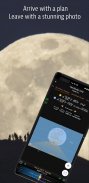
Ansel Adams ilk kitabı "Taos Pueblo" nun başlangıcını görselleştirmeye adadı. Fotoğrafçının, çekime başlamadan önce son baskısının nasıl görünmesini istediğini hayal etmesini içeren "görselleştirme" fikrini tanıttı. Tabii ki, doğaçlama çekilmiş birçok harika fotoğraf var. Bununla birlikte, manzara fotoğrafçıları için, oraya gitmeden önce sahneyi önceden canlandırabilmek, hazırlıksız yakalanma şansını büyük ölçüde azaltacak ve daha iyi çekimler yapma şansını büyük ölçüde artıracaktır.
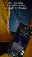
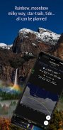
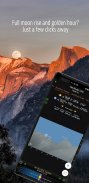
Fotoğrafçılar sahneyi önceden görselleştirmelerine yardımcı olmak için çeşitli araçlar kullanır. Günümüzde, bu araçların çoğu telefon uygulamalarıdır. Planit Pro, fotoğrafçıların sahneyi zemin konuları ve Güneş gibi göksel nesnelerle birlikte görselleştirmek için gerekli araçları sağlamak için haritayı ve simüle edilmiş vizör teknolojilerini kullanmak üzere tasarlanmış hepsi bir arada bir çözümdür. Ay, Yıldızlar, Star yollar ve Samanyolu.
Planit Pro uygulamasında, GPS koordinatları, yükseklik, mesafe, yükseklik kazanımı, net görünüm, odak uzaklığı, alan derinliği (DoF), hiper odak uzaklığı, panorama ve hava fotoğrafçılığı gibi konum izlemeden Ephemeris, güneşin doğuşu, gün batımı, ayın doğuşu, ay batışı zamanı ve yönü, alacakaranlık zamanı, günün özel saatleri, güneş / ay bulucu, büyük yıldızlar, takımyıldızlar, bulutsular azimut ve yükseklik açısı, yıldız izi planlaması, hızlandırılmış hesaplama ve simülasyon, dizi hesaplama ve simülasyon, samanyolu arama, güneş tutulması ve ay tutulması, pozlama / ND filtre hesap makinesi, ışık ölçer, gökkuşağı konumu tahmini, gelgit yüksekliği ve gelgit arama vb. Tüm bilgiler harita üzerinde bir yer paylaşımı veya tıpkı kameranızın vizörüne baktığınız gibi simüle edilmiş vizörlerde (VR, AR, resim veya sokak görünümü) görsel olarak sunulur. Manzara fotoğrafçılığınız için ne isterseniz, Planit Pro'da var.
Manzara fotoğrafçılığı doğa dünyasında bir maceradır. Keşfederken bazen ağ bağlantısı olmayacağını anlıyoruz. Planit Pro bunu akılda tutmak için tasarlandı. Çevrimdışı yükseklik dosyalarını ve çevrimdışı mbtiles haritalarını önceden yüklerseniz, ağ bağlantılarına gerek kalmadan uygulamayı tamamen çevrimdışı kullanabilirsiniz.
Planit: Photo Planner - Sürüm 10.7.6
(11-11-2024)
Planit: Photo Planner - APK Bilgisi
APK sürümü: 10.7.6Paket: com.yingwen.photographertoolsPlanit: Photo Planner uygulamasının en son sürümü
Diğer sürümler


 3.78
3.78


 3.25
3.25


Aynı kategorideki uygulamalar
 3.932.184.134.63
 4.45
4.45Hoşuna gidebilecekler...